Located near Creede in southwestern Colorado, Wheeler Geological Area is a stunning and surreal landmark nestled within the Rio Grande National Forest. Established as a National Monument by Roosevelt in 1911, this site was later reclassified as a wilderness area due to its remote location.
The challenging journey required to reach it deterred most visitors. You can hike a 7-mile trail or drive 14 miles with a 4×4 vehicle to get there.
Introduction to the Wheeler Geologic Area
The Wheeler Geologic Area is situated on the southern slopes of the San Luis Peaks in the La Garita Wilderness.
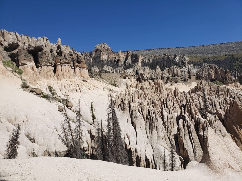
It is a remote, 60-acre site that is celebrated for its bizarre and alien-like rock formations.
The area’s unique geological features give it an otherworldly appearance, making it seem as if it’s from another planet.
The USFS area, part of the vast San Juan Mountains, sits at an elevation of 11,960 feet, displaying a rugged and remote beauty characteristic of the area’s significant volcanic geological history.
Geology
The Wheeler Geologic Area has dramatic landscapes shaped by intense volcanic activity.
This area features bizarre rock formations such as hoodoos, spires, and cliffs, all sculpted from volcanic ash.
The ash was deposited by eruptions from the La Garita Caldera about 28 million years ago.

The La Garita Caldera, one of the largest volcanic eruptions on Earth, spewed approximately 1,200 cubic miles of material, significantly impacting the Colorado landscape.
Over millions of years, this ash compacted into tuff and was shaped by erosion into the striking geological formations seen today.
To see some other hoodoos and interesting landscapes, check out the Bisti Badlands in northwestern New Mexico and White Pocket north of the Grand Canyon in Arizona. Both are relatively quiet with few visitors, but super cool with amazing photo opportunities.
Namesake
The Wheeler Geologic Area is named after Captain George M. Wheeler, who led an extensive survey from 1873 to 1884 as part of the United States Army Corps of Topographical Engineers.
His work, which began in 1874, was crucial in mapping much of the American Southwest, contributing significantly to the understanding and documentation of this vast region.
History of the Wheeler Geologic Area
The Wheeler Geologic Area was once a National Monument. Here is the timeline of how its status evolved:
- 1908: President Theodore Roosevelt established the Wheeler Geologic Area as the Wheeler National Monument, encompassing 300 acres. This quickly became the second-most popular tourist attraction in Colorado after Pikes Peak, thanks to the early 1900s travel spirit where people ventured long distances by horse.
- 1910s: Wheeler saw a surge in visitors, driven by the “See America First” campaign during World War I. The area was advertised as “more magnificent than any other region in the world” and “a rival of Yellowstone National Park.”


- 1933: Management of the monument transferred from the Forest Service to the National Park Service.

- 1943: The monument saw only 43 visitors, indicating a significant decline in its popularity, likely due to the increasing reliance on automobiles which could not easily access the remote location.
- 1950: Wheeler National Monument was demoted from National Monument status and returned to the Forest Service, largely due to its remoteness and poor accessibility.
- 1962: The Forest Service expanded the protected area from 300 to 640 acres and banned all mineral prospecting to preserve the site’s fragile environment.
- 1964: Congress established the La Garita Wilderness, enhancing conservation measures around the Wheeler area.
- 1969: The Wheeler formations were designated as a Geological Area; motorized vehicles were banned from the now 640-acre site. A gravel road was constructed within 14 miles of the site, but further road construction to the formations was halted.
- 1993: The Wheeler Geologic Area was included in the La Garita Wilderness as part of the Colorado Wilderness Bill. This designation banned logging, mineral exploration, road building, new water diversions, and mechanized travel, providing full wilderness protection to the area. A road corridor was left out of the wilderness designation to maintain visitor access to the rock formations.
Today, access to the Wheeler Geologic Area is either by a 4×4 vehicle or a long hike.
Location of the Wheeler Geologic Area
The Wheeler Geological Area is about 8 miles as the crow flies outside of the historic mining town of Creede in Colorado.

But to get there, you have to take forest service roads and/or hike, which adds on a lot of traveling time. It’s not easy to get to, but worth it for the view!
Google Map
The Google Map below shows the location of the Wheeler Geologic Area. It doesn’t show driving directions, as you can not drive there in a regular passenger car.
Three Options for Getting to the Wheeler Geologic Area
You have three options for getting to the actual site of the Wheeler Geologic Area: an ATV (All-Terrain Vehicle), bicycle or a hike.
The USFS Interactive Visitor Map below shows you the Forest Roads and trails in the area.
You can click on the map below to go directly to the interactive version of this map for more information.

The first set of directions are the same for driving an ATV, biking, and hiking, as you are going to drive (in any type of vehicle) to the site of the old sawmill referred to as Hanson’s Mill.
The drive climbs to an elevation of nearly 11,000 feet.
Follow the directions below:
- First, check with the Creede Ranger District Office to make sure Forest Road (FR) #600 is open. FR 600 is a gravel road suitable for any car.
- Go to their district road conditions website.
- Check the status of FR #600 (Pool Table) to make sure it is open. It is usually one of the first forest roads to close and the last to open in the area. It is sometimes closed in the summer months if it is too wet during monsoon season.
- If FR 600 is open:
- From Creede, take Colorado Hwy 149 for 7.3 miles, to Pool Table Road (Forest Road #600). Turn left on Pool Table Road.
- From South Fork, take Colorado Hwy 149 for 14 miles and take a right on Pool Table Road (Forest Road #600)
- Drive for 10 miles to the Hanson’s Mill dispersed camping area.
- Park at Hanson’s Mill. (You can also park earlier along Pool Table Road if you prefer, but you cannot take a passenger car beyond this point, unless it is an off-road vehicle.)
- There are vault toilets available here.
From there, the directions change for whether you are driving an ATV/biking or hiking.
The map below shows where the ATV road continues past the Hansons Mill dispersed camping area and the East Bellows Trailhead #790 begins.

ATV/Biking Directions
The next phase is only for those who have an ATV with 4WD or an ATV that is capable of driving a rough and rutted road.
This is not a drive for a regular passenger car. Also, an all-wheel drive car does not have enough clearance to take this route.
- From Hansons Mill dispersed camping area, stay to the right when the road forks.
- Continue driving along FR 600 (Pool Table Rd) for 14 miles. The road is rough and can be impassible in rain.
- Park when you reach the parking lot area when the road dead-ends.
The road has deep ruts and big rocks along the way, meaning you will not be going very fast.
The 14 miles will take you about 3 hours.

You will drive through some forests with a lot of beetle kill pine.

It will then open up into meadow areas, until you reach the more difficult part of the road, which is nearer to the Wheeler Geologic Area.

You could also use a bicycle along this road.
The road is fairly flat so it is not too difficult of a ride.

Hiking Directions
For those hiking to the Wheeler Geologic Area, once you’ve parked at Hanson’s Mill, follow these directions:
- From Hansons Mill dispersed camping area, take the left fork, as shown in the map above.
- Take East Bellows Trail (Trail #790). It is approximately 7 miles long (one-way).
- At mile 2, cross the East Bellows Creek, which flows into the Rio Grande River. There is no bridge, so be prepared to get wet.
- Hike for an additional 3.5 miles.
- At approximately the 5.5 mile mark, the trail joins Pool Table Road for the last 1.5 miles to the Wheeler parking area.
The first two miles of the hike are downhill, but the rest of the trail is relatively flat. On the way back, you will need to hike those last two miles uphill.
In many areas of the trail, you will be completely exposed.
During the summer, thunderstorms with lightning are common during the afternoons. It is best to get an early start.
Visiting the Wheeler Geologic Area
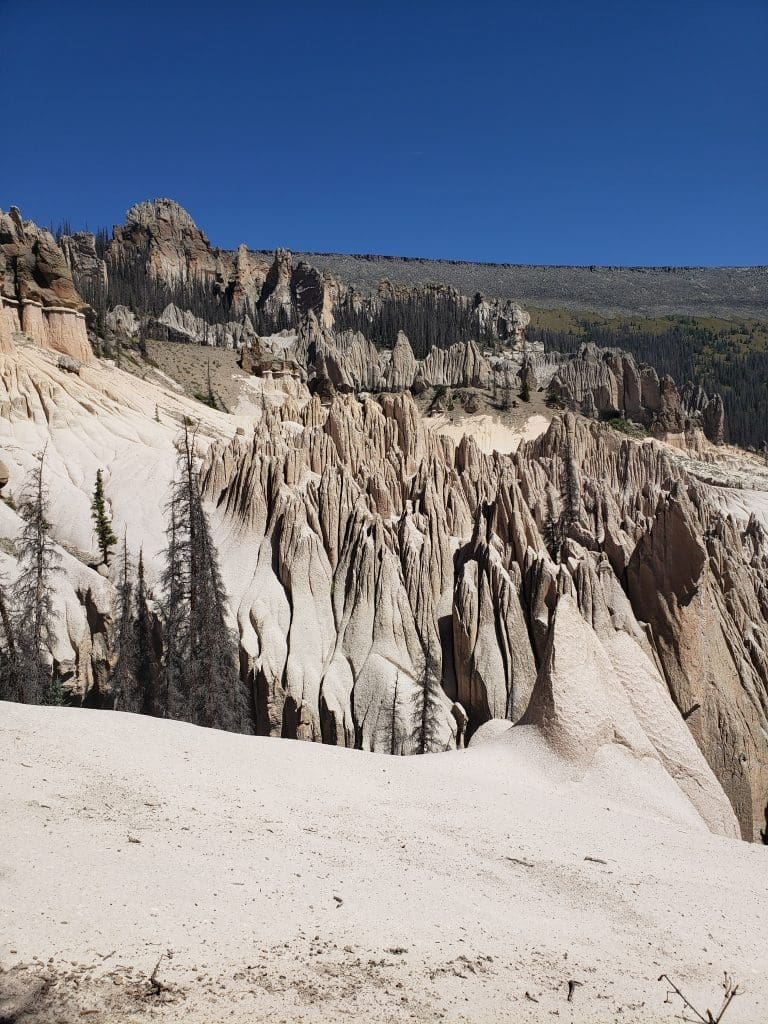
1/2 Mile Hike to See the Formations
Once you’ve made it to the end of FR 600, it’s about a 1/2 mile hike uphill to see the hoodoos, spires, etc. You are not allowed to drive an ATV up this trail.
After about 200 yards on the trail, it will split.
If you go to the left, it will take you to a scenic overlook that provides a spectacular viewpoint to see the geological formations. There is a bench there where you can enjoy the view.
You will be at 11,960 in elevation at this point, so don’t be surprised if you are out of breath.
If you go to the right, you will come to a small shelter that was built in about 1915.

This will continue on to the base of the geological formations.
Both provide interesting viewpoints.

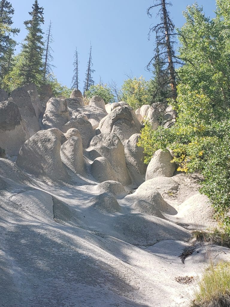
Hike around the Wheeler Geologic Area
You can continue on a hike around the Geologic Area.
A trail goes for 2 1/2 miles around the entire area. This provides for many interesting views of the formations.

We saw a lot of bear scat in the area, so bring some bear spray with you, just to be safe.


Camping
There are a few camping options in the area.
Hanson’s Mill Dispersed Camping
At the end of the first 10 miles of Pool Table Road, you will come to the Hanson’s Mill Dispersed Camping area operated by the USFS.
This is a first-come, first-served camping area. It is in a wide, open area, so there is plenty of parking for cars, trailers, RVs, etc.
It has three established camping areas with picnic tables and fire rings.
The only amenity here is a vault toilet. There aren’t any trash cans, so be prepared to pack all of your trash out with you.
It is at an elevation of 10,800 feet, so it will get cold at night.
Dispersed Camping at End of FR 600
There are also dispersed camping options at the end of FR 600 near the parking area for Wheeler Geologic Formation.
Camping and campfires are prohibited within the area of the formations.
Private Campgrounds and RV Parks
There are many private campgrounds and RV parks in the Creede and South Fork areas.
Do a search on Campendium or other campground directory for some ideas and reviews.
Final Thoughts on Wheeler Geologic Area
Once you’ve visited Wheeler Geologic Area, you can see why it was once one of the most popular tourist destinations in Colorado. It is similar to Bryce Canyon, but at a higher elevation way up in the Rockies.
It is worth the effort to get here if you can. The whole area surrounding Creede is full of things to do.
If you’re feeling particularly adventurous after seeing Wheeler, there’s a great hike to a 14er near Creede called the San Luis Peak. It’s long, but not terribly difficult to do.


")

