San Luis Peak is located within Colorado’s La Garita Wilderness and has multiple hiking paths to its summit. The options include the Stewart Creek route on the northern side and the West Willow Creek route from the southern side. We hiked the West Willow Creek route. We include the directions and route information below.
San Luis Peak towers up to 14,014 feet in the San Juan Mountains.
It’s known for being secluded and amazing natural scenery. It gives you a peek at some truly untouched beauty in one of Colorado’s wildest spots.
- Colorado 14ers
- Two Hiking Routes to San Luis Peak
- Creede, Colorado
- Driving Directions to the West Willow Creek Trailhead
- Parking
- Camping
- West Willow Creek Trailhead to San Luis Peak
- The Peak of San Luis Peak
- Hiking above the Tree Line
- Hiking with Dogs to San Luis Peak
- Tips for Hiking the San Luis Peak
- Enjoy Your Hike!
Colorado 14ers
Colorado boasts 58 mountains that rise above 14,000 feet, often called “fourteeners” or “14ers,” and San Luis Peak is among these peaks.
These 14ers are scattered throughout the state and range in challenge level from relatively easy hikes to demanding technical climbs.
Two Hiking Routes to San Luis Peak
San Luis Peak can be accessed via two trails, which are often mixed up.
The northern approach is through the Stewart Creek trailhead from Gunnison, while the southern approach is via the West Willow Creek trailhead from Creede.
The Stewart Creek trail is the easier of the two, with a difficulty rating of 1, but it’s longer, adding an extra 2 ½ miles to the round trip.
On the other hand, the West Willow Creek trail, with a difficulty rating of 2, offers a more challenging hike but is known for having beautiful scenery. It’s less frequented, owing to its remote location.
When we hiked this trail on a Saturday in July 2023, we only saw about five other hikers.
Creede, Colorado
The directions we provide are from the town of Creede, Colorado.
Creede is a charming historic mining town deep in the San Juan Mountains. It is one of our favorite off-the-beaten-path spots, so it is worth a visit if you have the time.

Founded in 1890 during the silver mining boom, Creede’s rich history and mountain surroundings retains much of its late 19th-century character. Many of the old buildings are preserved.
The Bachelor Loop is a 17-mile drive where you can see remnants of the late 19th and early 20th-century silver mining boom, including old mine shafts and ghost towns.
There’s also an area about 8 miles from Creede that used to be a National Monument and was the second most visited tourist site in Colorado. It was demoted in 1950 due to its remoteness. Check out the Wheeler Geologic Area.
Driving Directions to the West Willow Creek Trailhead
Finding the correct path to the trailhead can be challenging due to varying information available online.
Below are the accurate directions to reach the trailhead.
To Midwest Mine
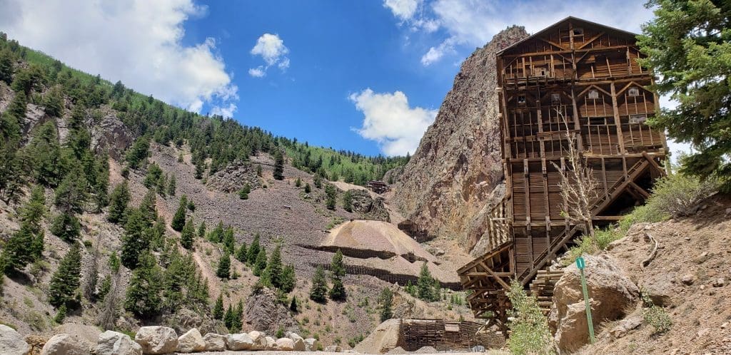
Starting in Creede, head north on Forest Road (FR) 503. This is a dirt road but is passable by all types of cars.
Along the way, you’ll pass through a region dotted with old mines, offering a fascinating glimpse into the past if you have time to explore.
Continue on FR 503 for approximately 7 miles from Creede.
Look out for a sign indicating the Midwest Mine, a large active mining site located on the right side of the road.
Turnoff to 4-Wheel Drive Road
Approximately 50 feet before reaching the Midwest Mine, you’ll need to make a sharp left turn to stay on FR 503.
There’s a sign at this turn indicating “Willow Creek and Rat Creek ATV trail” — this is the correct road to follow.
The coordinates for the left turn are 37°56’04.4″N 106°57’35.7″W. It’s at this juncture that people often miss their way to the trailhead.
The image below presents a satellite image of the turnoff area to the left. You can see the mine to the right of the red icon for the turnoff.
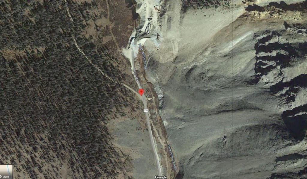
Google Maps
While Google Maps can guide you to this turnoff, the accuracy of its directions to the trailhead from here are not correct.
This is an interactive Google Map to the turnoff area. You can zoom in or input your address to get more details on the directions to the turnoff.
4-Wheel Drive Road
From this point onward, it’s strongly advised to use a 4-wheel drive vehicle with high clearance due to the rough condition of the road.
Otherwise you will need to park your vehicle and hike along FR 503 to reach the trailhead. This will add about 3 miles to your hike round trip.
Trailhead
From the turnoff, the West Willow Creek trailhead is approximately 1.6 miles ahead on the right side of the road.
FR 503 makes a sharp left turn and extends west beyond the trailhead. Look for a sign indicating “No motorized vehicles, walking only” at the trailhead.
Parking
Parking space is extremely limited. There are two separate parking areas available, with enough room to accommodate approximately 10 cars in total.
Camping
Tent or Car Camping
After parking your vehicle, you have the option to either sleep inside it or set up a tent in the area.
The trail’s starting point offers numerous flat and open areas suitable for tent camping.
This location is at an elevation of approximately 11,600 feet, which means it can get very cold at night, even during summer months. Make sure to prepare for the cold.
Additionally, Creede offers various established campgrounds for those looking for more camping options.
RV Camping
RV camping is not possible at the trailhead.
For those traveling in an RV, it is important to not continue on FR 503 past the Midwest Mine turnoff.
The road is extremely rough and lacks space for turning around.
However, if you’re in an off-road campervan or a similar vehicle, you should be ok. You will be able to park and camp at the trailhead.
Dispersed Camping
Creede offers numerous dispersed camping / boondocking sites suitable for RV camping, particularly above the town, which provide spectacular views of the area below. Many of these sites are located on land managed by the United States Forest Service (USFS).
We have created a detailed tutorial to guide you through finding dispersed camping spots for RVs on USFS land. We recommend using our step-by-step guide to discover excellent dispersed camping locations around Creede.
RV Parks in Creede
Creede and the nearby town of South Fork both offer several great RV park options. In Creede, you can find the following RV parks:
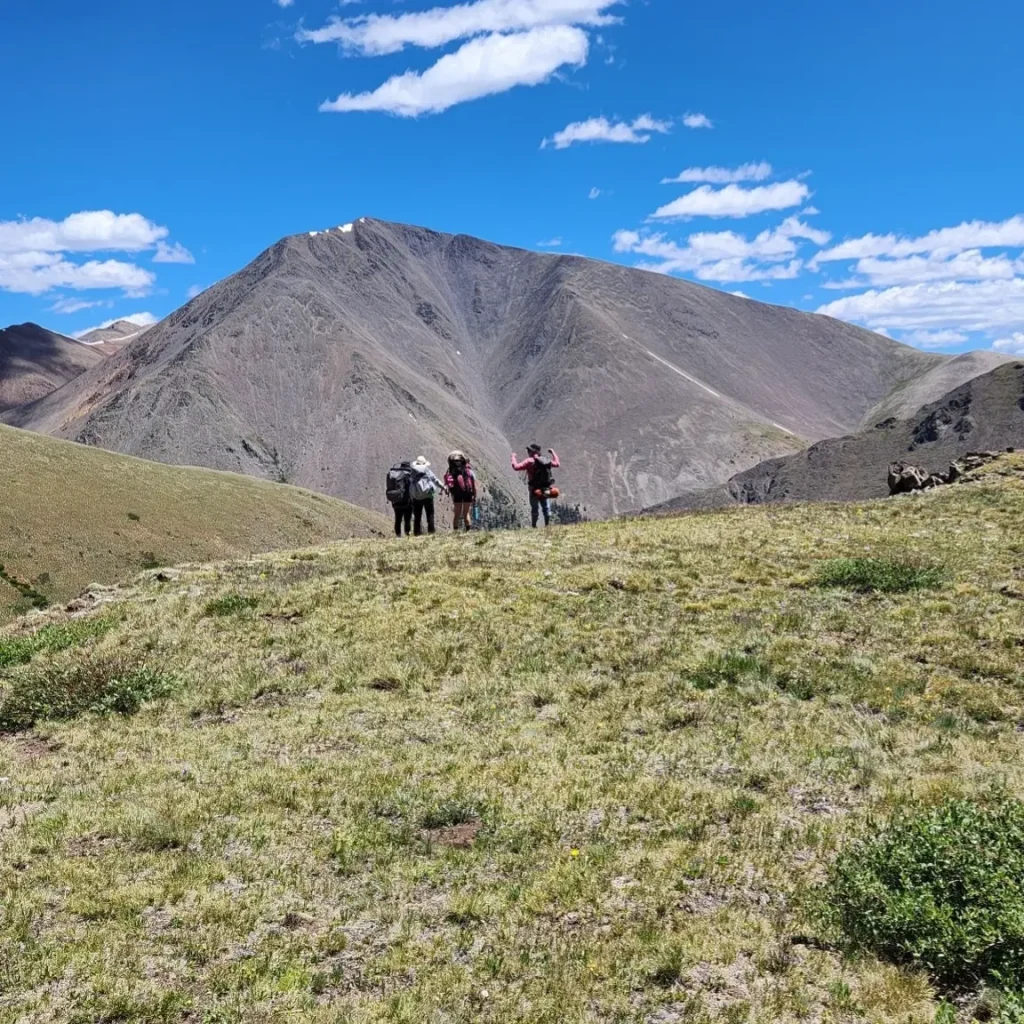
West Willow Creek Trailhead to San Luis Peak
San Luis Peak, accessed via West Willow Creek trail, appeals to those looking for a secluded mountain adventure due to its remote location and the hike’s physical challenges.
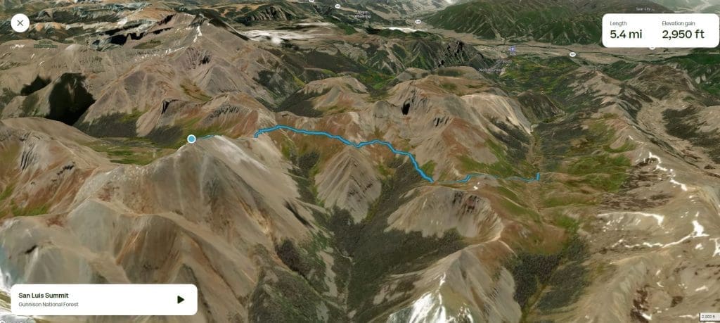
The total hike is approximately 10.8 miles round trip, with a climb of 3,412 feet.
Starting at an elevation of 11,600 feet, the trail ascends the South Ridge of San Luis Peak and reaches the summit at 14,014 feet.
Overall, the trail’s elevation increase is slight, except for steeper sections at the start and the final climb to the peak.
From the West Willow Creek Trailhead to San Luis Peak
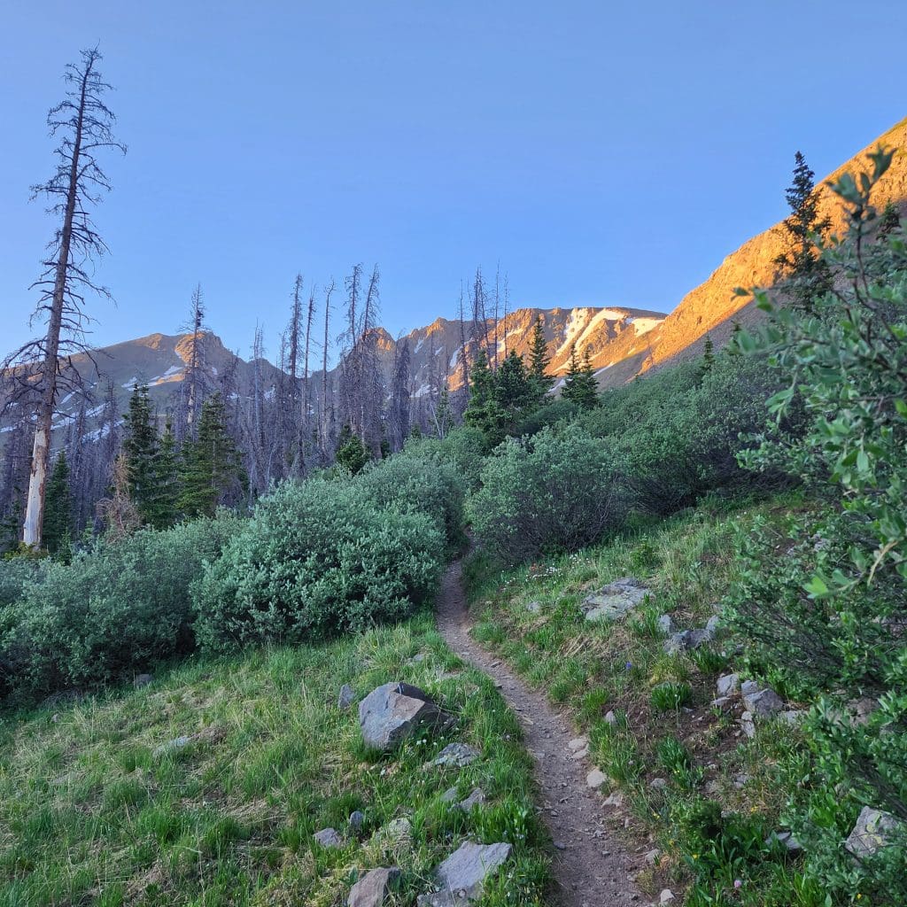
Starting at the West Willow Creek trailhead, follow FS Trail 882 (San Luis Pass Trail) for 1.3 miles to reach San Luis Pass.
The first mile includes a challenging elevation gain. But don’t worry, it gets a lot easier after this part, all the way up until the final climb to the top.
The image below shows the route you will take. It includes three separate trails (FS 882, FS 9465, and FS 9465.5A).
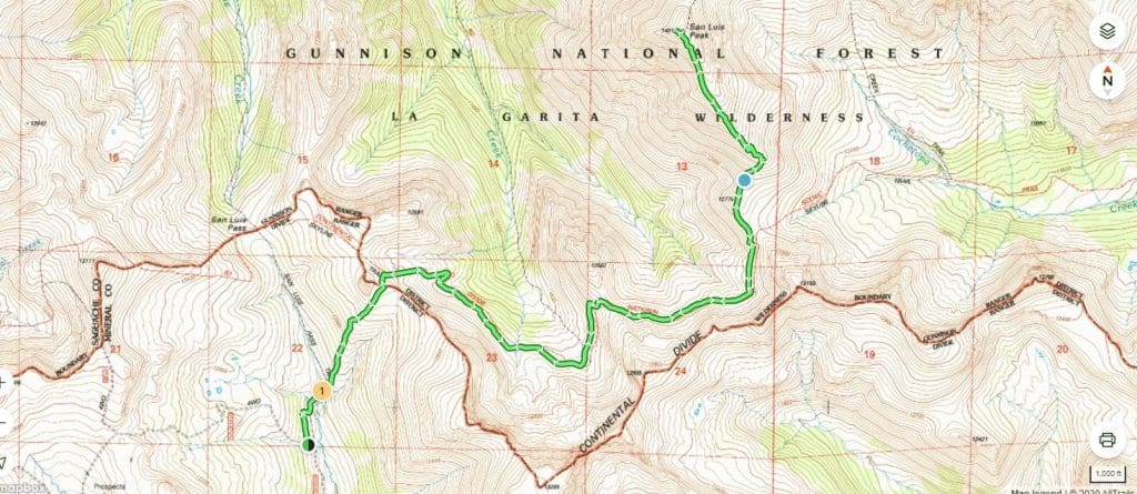
Along the way, you’ll cross the Continental Divide as you make your way to San Luis Pass.
Be moose aware as we encountered moose at the beginning of our hike.
When hiking with dogs, always exercise extreme caution around moose. Moose can become aggressive towards dogs and may trample them, leading to fatal injuries.
Connect to the Continental Divide Trail
Upon reaching the Continental Divide Trail (CDT), which is clearly marked, turn right.
This trail is also referred to as the Skyline Trail (FS Trail 9465). At this section, the CDT coincides with the Colorado Trail.
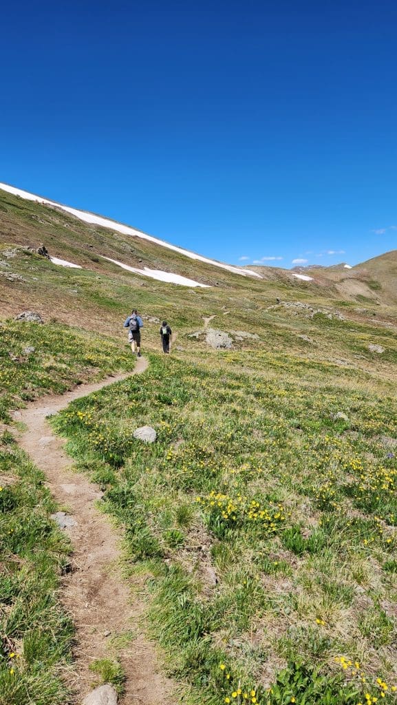
Continue on this trail for approximately 2.9 miles.
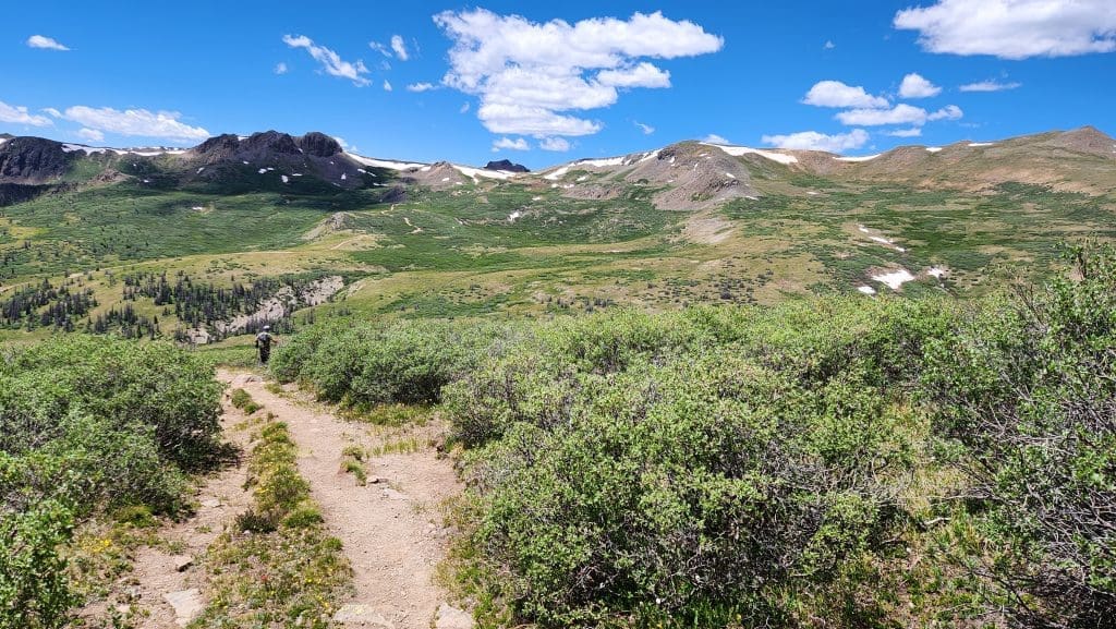
After this bit, the trail really eases up, taking you through thick woods and fields of wildflowers in the summer.
Within the first four miles, you’ll encounter three mountain streams, all of which are easily crossed.
The path navigates through various basins offering breathtaking views and crosses three saddles before it begins the ascent up the South Ridge of San Luis Peak.
Final Ascent to San Luis Peak
At the point where you meet the San Luis Peak Trail (FS Trail 9465.5A), take a left turn and proceed up the southern ridge trail to the summit.
This trail extends for 1.2 miles to the top of the peak.
There are three false summits, so don’t be discouraged when you realize you’re not at the top yet.
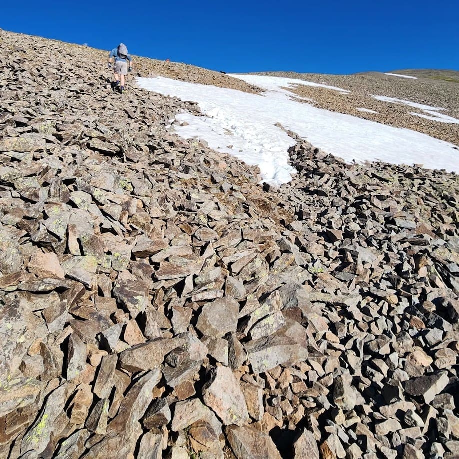
Nearing the summit, the path becomes steeper and is covered with loose scree, which are small, broken rocks on the mountainside.
The scree makes hiking more difficult because of its instability, increasing the risk of slipping or twisting an ankle.
The final part of the trail includes navigating through switchbacks and requires a bit of scrambling to proceed.
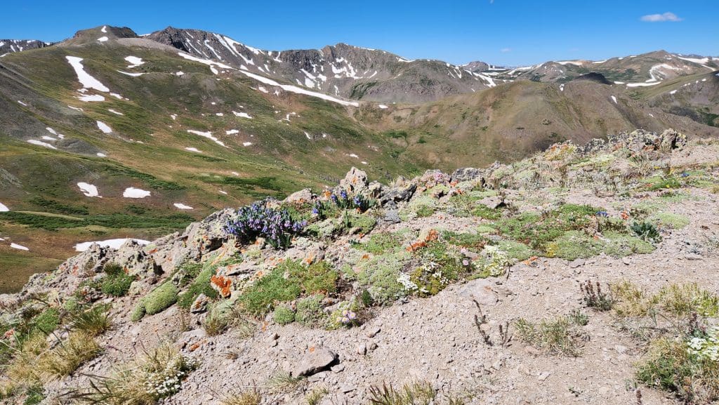
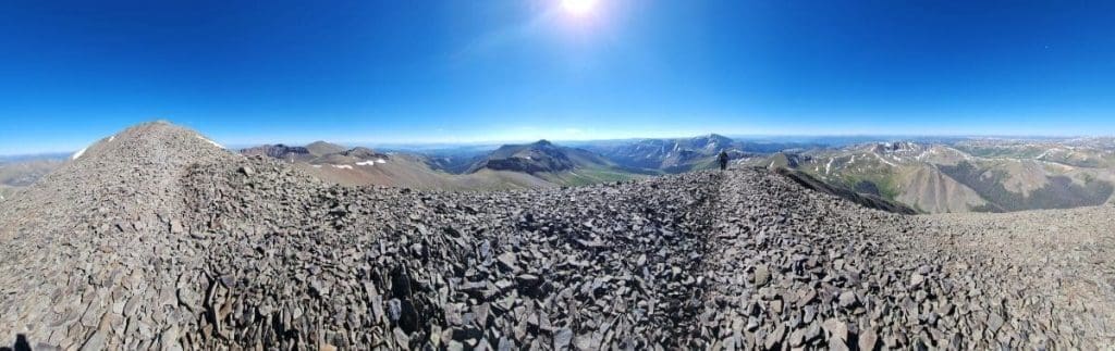
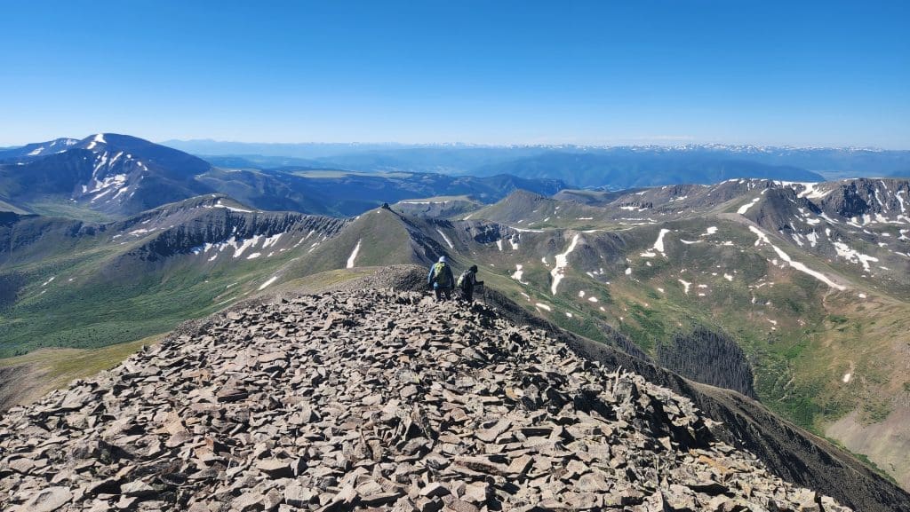
The Peak of San Luis Peak
Reaching the summit offers a rewarding experience with sweeping panoramic views of the vast San Juan Mountains wilderness.
We took the video below from near the top of the peak. It was incredibly windy!

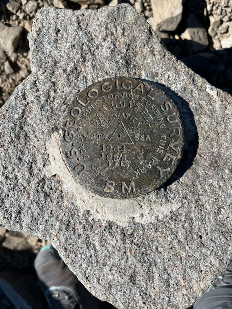
There is a US Geological Survey marker at the top of San Luis Peak.
(After your hike, check out a hike to natural hot springs in the Piedra river in between Pagosa Springs and Durango. It will help to soothe your sore muscles.)
Hiking above the Tree Line
The tree line is where trees stop growing because it’s just too cold and dry up there for them to handle.
In the San Juan Mountains and across much of the Colorado Rockies, the tree line typically lies between 11,000 and 12,000 feet.
Expect to hike above the tree line for this route.
Hiking above the tree line exposes you to harsh weather, sudden weather changes, higher UV radiation, and increased risk of altitude sickness due to the thinner air.
Hiking with Dogs to San Luis Peak
Dogs are allowed on the trail. However, we advise against bringing dogs (or friends!) that are not in good physical condition.
We decided against bringing our dog because the final ascent to the peak is extremely rocky and could be harsh on a dog’s paws.
If you do bring your dog, ensure they wear booties or have paws that are conditioned for rocky terrain.
Additionally, carry a bowl for your dog’s water needs. While there are streams along the hike where your dog can drink, it’s safer not to depend solely on these for your dog’s water.
Also, stay vigilant for moose to ensure your dog’s safety.
Tips for Hiking the San Luis Peak
When to Hike
The best time to hike this trail is between May and September. We completed this hike in the summer of 2023.
Navigation
Although the trail is clearly marked and straightforward to navigate, it’s wise to bring a printed map as a precaution in case your phone’s battery dies.
Start Early
Start your hike early in the morning to steer clear of the afternoon thunderstorms and hazardous lightning frequently occurring in the Rockies over the summer.
This precaution is particularly crucial when hiking above the tree line, as you will be on this trail.
We started our hike early and used headlamps which are important if starting before sunrise.
Layers of Clothing
Pack layered clothing to accommodate significant temperature changes. Also, include rain gear in your essentials.
A cover for your backpack is advisable as well.
Sun Protection
The sun’s intensity is much stronger at high elevations. Ensure you bring sunscreen, wear a hat, and use additional sun protection gear.
Hiking Socks
Given all the ups and downs on this trail, make sure to wear some comfy hiking socks to avoid getting blisters.
Water and Snacks
You’re going to need more water than you expect on your hike to San Luis Peak. Dehydration happens fast at high altitudes.
Don’t forget to pack some snacks for the journey, too.
Let Others Know Your Plans
Make sure to tell someone about your plans, including which route you’re taking and when you expect to be back.
CORSAR Card
Consider buying a Colorado Outdoor Recreation Search and Rescue (CORSAR) card, which costs $3 for an annual card or $12 for a five-year card.
This card supports the Colorado Search and Rescue Reimbursement Fund, covering the costs of Search and Rescue (SAR) operations.
If you have a CORSAR card and need SAR assistance, the fund can quickly process reimbursement for the mission’s expenses.
Not only could this potentially save you a significant amount of money in the event of a rescue, but it also supports a vital service for hikers and outdoor adventurers.
Enjoy Your Hike!
The hike up to San Luis Peak has it all: it’s challenging, peaceful, and the views are just incredible. It’s also a relatively easy hike to the top of one of Colorado’s epic “forteeners.”


