Did you know that there’s an easy way to find out where you can boondock in your RV for free on U.S. Forest Service (USFS) land using free mapping tools? Many people are not aware of how to find dispersed camping locations.
This tutorial will show you how to find great dispersed camping sites in National Forests using the interactive U.S. Forest Service Visitor Map and official Motor Vehicle Use Maps (MVUMs) developed by the USFS and available for free.
There are several websites and apps that campers can use to find free dispersed camping locations, but I’ve yet to find one that includes all of the great potential campsite locations that you can easily find using the free tools from the USFS.
Hence the need for this tutorial. Use this method so that you’re not limited to the already documented RV dispersed camping sites indicated on popular websites and apps such as Campendium and AllStays.
Campendium, AllStays, etc are great tools and we use them all the time, but they simply do not include all of the many potential dispersed camping locations on US Forest Service lands.
They are also the same potential dispersed camping sites being scouted by others using these apps. Hence other campers may have already taken over these locations.
To find a wider range of possible dispersed camping sites, use the free approach outlined in this tutorial.
- Dispersed Camping on United States Forest Service Land
- Outline of Steps in the Process
- Step 1: Search for a Geographic Location
- Step 2: Identify Forest Service Roads Accessible by RVs
- Step 3: Review the Motor Vehicle Use Map from the Relevant Forest Service Ranger District
- Step 4: Check the satellite image of the Interactive U.S. Forest Service Visitor Map
- Share the Current Visitor Map Area
- Create a Geo PDF of the Map
- Tips for Dispersed Camping along Forest Service Roads
- Final Thoughts on Using USFS Maps to Find Dispersed Camping Locations
Dispersed Camping on United States Forest Service Land
The USFS is a multi-faceted agency of the U.S. Department of Agriculture that manages and protects 154 national forests and 20 grasslands in 43 states, Puerto Rico, and the Virgin Islands.
The 193 million acres of land that the USFS manages is equivalent to an area larger than Texas. It is equal to 8.4 percent of the total land area in the United States, so we’re talking about a huge amount of the great outdoors that is available for your recreational enjoyment.
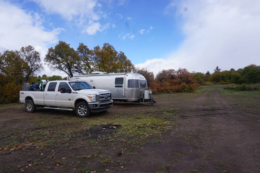
Boondocking, or dispersed camping as the U.S. Forest Service calls it, is camping in an area in which there are none of the amenities you will find at a developed campground, such as bathrooms, picnic tables, and drinking water.
Although the USFS has established campgrounds in the forests and grasslands for a fee, dispersed camping refers to camping in areas other than these established campgrounds.
But how do you go about finding dispersed camping sites? With the newly released Forest Service Visitor Map version 2.0, finding dispersed camping spots on USFS land just got a whole lot easier for RVers.
Forest Service Visitor Map 2.0
If you haven’t already, I encourage you to check out the newly released Forest Service Visitor Map. This is what we will use to start our search for dispersed camping locations in the National Forest.
It provides the public with an online view of Forest Service roads, recreation sites, wilderness areas, and wild and scenic rivers. You can use the map on personal computers, smart phones, or tablet devices.
When you first open the map, you’ll be presented with the following image.
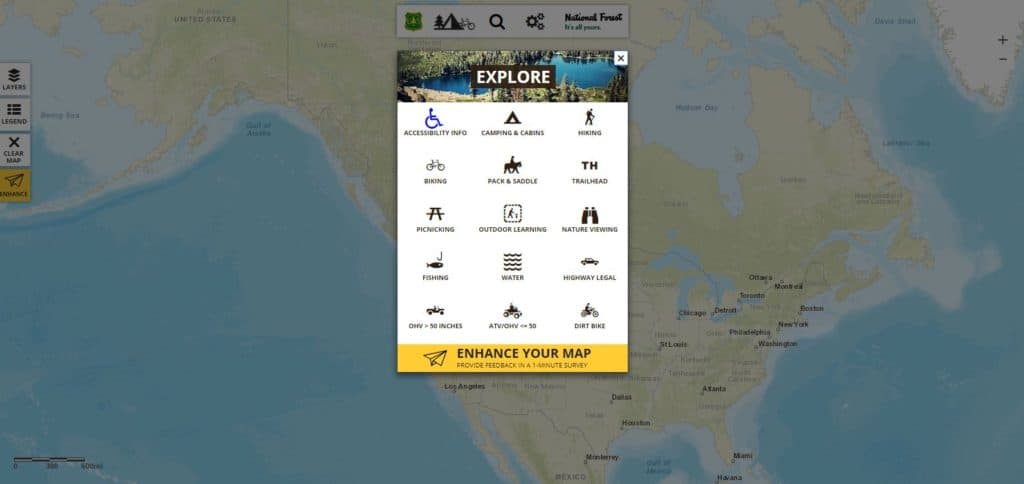
From here you can navigate to explore many incredible features, such as finding campgrounds, hiking trails, nature viewing spots, and more.
But the purpose of this tutorial is to show you how to find dispersed camping (aka boondocking) locations on USFS land, so we’ll stay focused on using the map for this purpose.
Outline of Steps in the Process
Use this step-by-step tutorial to find dispersed camping locations in the US National Forests. These locations will be accessible for cars and RVs. The full details are provided on the webpage along with highly detailed instructions with images to illustrate the steps.
- Search for a geographic location.
Use the USFS map to zoom in to a specific geographical location.
- Identify Forest Service Roads Accessible by cars and RVs.
Use the USFS map to identify roads that are accessible by passenger vehicles.
- Review the Motor Vehicle Use Map from the relevant Forest Service Ranger District.
Obtain a copy of the MVUM from the Forest Service (available online) to find roads that are designated for dispersed camping.
- Check the satellite image of the Interactive U.S. Forest Service Visitor Map.
Change the default layout of the map to see a satellite image of the area you’re interested in for camping. You will be able to see if there are pull-outs on the road suitable for dispersed camping.
Step 1: Search for a Geographic Location
To start, let’s assume we’re searching for a dispersed camping location near Pagosa Springs, Colorado. We may not know the name of the specific national forest in that area, but the map will help us find it out.
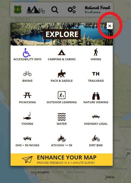
Close the “Explore” box by clicking the X in the top right corner of the box, as indicated with the red circle on the image below. We’ll come back to this box later in the tutorial.
Next, we’ll search for the town of Pagosa Springs, Colorado. Click on the search icon, as indicated in the red circle below.
Type in “Pagosa Springs, CO” and select the first option for “Pagosa Springs, CO, USA (Auchuleta County).” Then select the “Go!” button.

The map will reposition itself centered on the town of Pagosa Springs.
Zoom out of the town a bit by selecting the “-” button at the top right of the map (circled in red below), until you get to an image that looks something like the one below.

On this version of the map of the Pagosa Springs area, you can see that the town is surrounded by the San Juan National Forest.
The green areas on the map are the boundaries of the National Forest System lands, while the beige areas are non-Forest Service lands.
Click on the “legend” icon on the left of the screen and scroll down to see what the boundary colors indicate.

To find dispersed camping locations in the USFS land, we’re going to want to stay in the green areas of the map.
Step 2: Identify Forest Service Roads Accessible by RVs
The next step in finding dispersed camping locations is to identify Forest Service roads that are accessible by most RVs.
You don’t want to end up on a road that requires four-wheel drive and a high-clearance vehicle, unless your rig is outfitted for that type of travel.
There are two ways to determine which roads are accessible by RVs.
First Method to Determine Which Roads are Accessible By RVs
First, you can look at the legend to see what type of roads are on the map and then find those road types displayed in the green areas on the map.

There are three types that are usually easily passable by RVs: paved roads, gravel roads, and dirt roads.
Paved roads are going to be the easiest for RVs to drive on, but they are likely to be far less common than gravel roads or dirt roads on USFS land.
You can compare the line types used on the map to the legend to determine what type of road each is.
Second Method to Determine Which Roads are Accessible By RVs
The second way to determine which roads will be drivable by RVs is to use the interactive features of the Forest Service Visitor Map to identify “highway legal” roads on the map.
You’re going to want to get to the “Explore” box of the mapping tools.
Click on the icon with the tree, tent, and bicycle to bring up the explore options.
Once the explore box pops up, select the “highway legal” icon as indicated in the red circle below.

Once you select “highway legal,” all of the roads that highway legal vehicles are approved to drive on will be highlighted on the map in yellow.
An icon will also appear with identifying information for each road, as indicated in the red circle below.
Clicking on the icon along each road will give you identifying information about the forest road number and name, the dates it is open to various types of vehicles, the type of road, level of service, length, and which National Forest it is in.
This is a good way to determine if the road will be easily driveable on by an RV.
In this case, we see that Forest Service Road number 656 is known as the Blanco River Road, is open to highway legal vehicles (such as a motorhome or pickup truck pulling a travel trailer) from May 15th through November 30th each year, that it is a gravel road, that it is suitable for passenger cars, and is 2.3 miles long.

Forest Service Road 656 looks like it might be a good option for dispersed camping, since it’s located right off a main highway (Highway 84) which runs south of Pagosa Springs.
But we still need to find out if it’s legal to boondock there.
Step 3: Review the Motor Vehicle Use Map from the Relevant Forest Service Ranger District
The next step is to determine whether it is legal to boondock (i.e. disperse camp) on the Forest Service road of interest. To determine this, you’ll need to access the relevant Motor Vehicle Use Map (MVUM).
In 2005, the Travel Management Rule for the U.S. Forest Service was implemented which requires each National Forest or Ranger District to designate which roads, trails, and areas are open to motor vehicles.
The MVUM also displays allowed road use by vehicle class (e.g., highway legal vehicles, off-road vehicles).
Forest Service roads that are not displayed on the MVUM are not authorized for public motor vehicle use.
To access the MVUM for the National Forest of interest, there are three ways to obtain the map.
You can download the map from the USFS website, access it through the Avenza map application, or pick up a paper map at the Ranger District.
Method 1: Download the MVUM as a PDF from the USFS Website
You can download the MVUM as a PDF from the USFS.
Click here and find the relevant forest name. They are listed by state.

What you see next when you click on the relevant National Forest will differ for each National Forest as they maintain their own website’s information.
You should be able to easily locate the MVUM for each National Forest using this link.
As an example, I selected “San Juan National Forest” in Colorado and see the following page, with links to the MVUMs maintained by three different Ranger Districts: Columbine District, Pagosa District, and Dolores District.

I select the Pagosa District to download a PDF of the MVUM for the Pagosa Ranger District.
The resulting map is a PDF of the actual printed map, so it’s formatted to be folded like a regular map.
Method 2: Download the MVUM using the Avenza PDF Mapp Application for iOS, Android, and Windows
To access the maps electronically on your phone or tablet, download the Avenza PDF maps application and then navigate to the relevant MVUM for each National Forest.
A benefit of using the Avenza app is that you can use the locator feature in combination with your device’s GPS features to find where you are on the map at any given point in time.
Motor Vehicle Use Maps are free for downloading from Avenza.
Method 3: Request a printed map from the Ranger District Office
If you’re already in the area of the National Forest where you’re interested in camping, you can stop by and request a printed version of the MVUM from the local Ranger District Office.
There are more than 500 Ranger Districts nationwide, and they are staffed with a team of 10 to 100 forest rangers.
The USFS provides MVUMs free of charge, so it’s easy to stop by and pick one up.
As a bonus, you can chat with the ranger staff to find out their tips on finding great places for dispersed camping in your RV.
Review the MVUM
Once you have a copy of the MVUM, you can look for specific information related to boondocking, or dispersed camping. The Motor Vehicle Use Map that you obtain should look something like the one below from the Pagosa Ranger District.

Let’s assume you downloaded the PDF version of the MVUM using the first method above.
It would require a large plotter printer to be able to print a usable version, so I rely on viewing this version on my laptop screen.
Each National Forest will have its own specifications for what to include in the MVUM, so they’ll each look slightly differently from one another and include different types of information.
Unfortunately, not all National Forest MVUMs include information specific to dispersed camping, but many do.
If you are interested in a location for which the MVUM does not focus on dispersed camping, your best bet is to contact the relevant Ranger District directly and ask for their guidance on where dispersed camping is allowed in their area.
The Pagosa District MVUM includes information specific to Forest Service roads where dispersed camping is allowed by people camping in RVs. First, it provides a “blanket statement” about dispersed camping that says:
Motor vehicle use off of designated roads for the purpose of dispersed camping is permitted for up to 300 feet from the centerline of the road, allowing the same vehicles as the road allows and the same season as the road is open. This applies to all the roads with the Dispersed Camping symbol unless otherwise posted.
United States Forest Service
An image of this statement on the map is below.

From this statement, we know that we can camp up to 300 feet from the center of the road in our RV, provided that the road is open during the season we want to camp.
Our next step is to verify that dispersed camping is allowed on the Forest Service road of interest.
To do this, we see that the legend identifies Forest Service roads where dispersed camping is allowed using dots on the side of the road on the map.

If we go back to the Blanco River Road (aka Forest Road 656, i.e. FR 656) south of Pagosa Springs that we identified in Step 2 above, we see that it has little dots on both sides of the road.
This means that dispersed camping is allowed on either side of FR 656.

Here’s a closeup of the dots that you’re looking for on the map.
These are the dots that indicate that dispersed camping is allowed on either one or both sides of the road.

The tent icon that you see at the end of the road indicates that there is also an established Forest Service campground on this road.
In this case, it’s the Blanco River Group Campground. (There’s an easy 1-mile hike from the Blanco River Group Campground to the historic Murray Ranch.)
If you wanted to be in an established campground and not boondock, it may be a good option for you. Otherwise you can camp along the gravel road leading to the campground.
Now that we know that dispersed camping is allowed on the Blanco River Road south of Pagosa Springs, we need to determine if it’s a good candidate for camping.
Step 4: Check the satellite image of the Interactive U.S. Forest Service Visitor Map
From using the interactive U.S. Forest Service Visitor Map in Step 2 above, we already know that the road is gravel, suitable for passenger cars (and therefore most RVs), and open seasonally from mid-May to the end of November each year.
What we don’t know is whether there are any good pullout spots along the road to camp in our RV.
Go back to the interactive U.S. Forest Service Visitor Map and find the Blanco River Road south of Pagosa Springs.
Initially your view will look like the default base map view, like below.

To see the satellite image of the road area, you’re going to want to change the base map to satellite imagery.
Click on the three gears icon at the top of the interactive map, as shown below, to access the tools options.
Next, select the icon for “Base Map.”

Then, select the base map option for “Imagery.”

The background for the map will change to a satellite image.
With this version of the base map, you can see more details about the terrain of the land in which you’ll be camping.
Be sure to click the “X” to close out the base map selector tool.

Zoom in to the Blanco River Road area on the map using the “+” and “-“ buttons at the top right of the screen.

You can zoom in close enough to see individual trees and bushes.
In the satellite image of the Blanco River Road, you can even see a spot where it looks like there are two RVs parked off a little pullout along the main FR 656.
They were parked there dispersed camping when this satellite image was made, likely unknown to them!

You’re going to want to look for clearings along the road where it looks like you could pull over in your RV to camp.
Sometimes these will be obvious, as in the case with the two RVs camped in the pullout when this satellite image was taken, but sometimes it will take a little investigative work to see what’s possible.
For example, it may be helpful to search the web for any videos people may have taken of that particular forest service road.
Share the Current Visitor Map Area
If you’re planning a camping trip with someone, you can easily share the current map area using features built into the interactive U.S. Forest Service Visitor Map.
Click on the three gears at the top of the map where you’ve zoomed in and then select the “Share Map” icon.

You can choose to share the entire interactive U.S. Forest Service Visitor Map link (first option) or share just the current map area (second option).
You can share it via Facebook, Twitter, email, or simply copy the URL and share it another way.

Selecting the second option for “Share Current Map Area” will share the exact map you’re seeing on your screen using the customized URL provided.
Create a Geo PDF of the Map
You also have the option of creating a Geo PDF version of the map.
A Geo PDF map is essentially a PDF map of the area you’ve zoomed to, along with a name you give the map, notes you’ve written about the map, a map legend, and the date and time you created the map.
To create a Geo PDF map, select the three gears icon at the top of the screen, and then select the “Create Geo PDF” icon.

Type in a map title and any notes you may want to include.

Hit “Go” and the system will take a few moments to process your request before creating a Geo PDF map. Once it is ready for viewing, you will be prompted to “View PDF.”
The result will be a two-page PDF document that includes an image of your latest map, along with a legend, your notes, and other relevant information about this dispersed camping location.

You can then save, print, and share the resulting PDF file.
Tips for Dispersed Camping along Forest Service Roads
When you’re dispersed camping along Forest Service Roads, there are some general tips and guidelines to follow, in addition to anything specific that the Ranger District might tell you.
- Be sure to scout ahead. Don’t drive your large Class A motorhome down a dirt road, only to find out that there’s nowhere to camp or turn around. It’s always a good idea to scout first with your tow vehicle, toad, bicycle, on foot, or any other way so that you don’t get stuck.
- This is dispersed camping. That means there are no amenities available where you’ll be camping, with the exception of beautiful views and fresh air. Plan to bring whatever you may need with you, including battery power, water, food, etc.
- Dispersed camping is generally not allowed at trailheads, picnic areas, and day-use parking areas within the National Forests.
- The general rule of thumb is to park at least 100 feet away from any water source.
- Camp in dispersed camping locations already established by others. Do not drive across meadows, cut down trees, or do anything to disturb vegetation in the area.
Final Thoughts on Using USFS Maps to Find Dispersed Camping Locations
Version 2.0 of the Forest Service’s interactive Visitor Map is packed with features that are incredibly useful for anyone who likes outdoor activities.
For RV’ers, it provides an easy way to find the perfect dispersed camping location, when used in conjunction with the relevant Motor Vehicle Use Map.
Use these to find your perfect camping spot, and then go back to the interactive map to find trailheads for hiking, places to picnic, and any other activity that you may enjoy in the National Forest.
How else would you use these maps? If you have other tips or suggestions for finding the best dispersed camping location, please drop a comment below. Or if you know of a great dispersed camping location, please feel free to share it below in the comments!


